


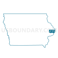
WASHINGTON TWP Voting District, Clinton County, Iowa
About
Outline

Summary
| Unique Area Identifier | 581851 |
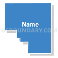
| Name | WASHINGTON TWP Voting District |
| County | Clinton County |
| State | Iowa |
| Area (square miles) | 32.06 |
| Land Area (square miles) | 32.06 |
| Water Area (square miles) | 0.00 |
| % of Land Area | 100.00 |
| % of Water Area | 0.00 |
| Latitude of the Internal Point | 41.90498980 |
| Longtitude of the Internal Point | -90.48276330 |
Maps


Graphs
Select a template below for downloading or customizing gragh for WASHINGTON TWP Voting District, Clinton County, Iowa


Neighbors
Neighoring Voting District (by Name) Neighboring Voting District on the Map
- BLOOMFIELD TWP W/O MAQUOKETA Voting District, Clinton County, IA
- CENTER TWP Voting District, Clinton County, IA
- DE WITT TWP W/O DE WITT Voting District, Clinton County, IA
- DEEP CREEK TWP Voting District, Clinton County, IA
- WATERFORD TWP Voting District, Clinton County, IA
- WELTON TWP Voting District, Clinton County, IA
Top 10 Neighboring County Subdivision (by Population) Neighboring County Subdivision on the Map
- De Witt township, Clinton County, IA (6,658)
- Bloomfield township, Clinton County, IA (840)
- Deep Creek township, Clinton County, IA (736)
- Waterford township, Clinton County, IA (692)
- Center township, Clinton County, IA (580)
- Welton township, Clinton County, IA (533)
- Washington township, Clinton County, IA (346)
Top 10 Neighboring Unified School District (by Population) Neighboring Unified School District on the Map
- Central Clinton Community School District, IA (9,293)
- Northeast Community School District, IA (3,041)
- Delwood Community School District, IA (1,223)
Top 10 Neighboring State Legislative District Lower Chamber (by Population) Neighboring State Legislative District Lower Chamber on the Map
- State House District 83, IA (30,728)
- State House District 25, IA (29,236)
- State House District 26, IA (28,285)